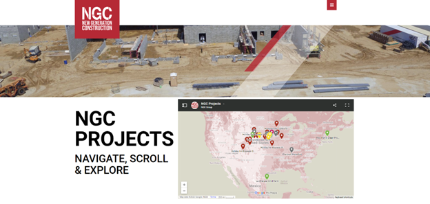
NGC is proud to launch the new Projects Map, developed with modern, online, navigation technology called ‘Google My Maps’. This map has all of NGC’s past and current projects pinned by geographic location, but wait, there’s more… each project opens a detailed panel revealing stats, professional photos, and links to the surrounding area in Google Maps. But wait, there’s more… each sector listed in the panel can be toggled on/off, and the project list, counts and the map pins respond to the inputs accordingly and immediately! Please check out, click around and explore NGC’s cool interactive map now… and tell us what you think.
Showcasing NGC’s portfolio in this geo-pin-map arrangement is very exciting as profiling manipulative data is paramount to understanding each project’s scope. This interactive-sortable manner of presentation of NGC’s project experience allows users customized control to narrow or expand desired information, while also gaining the overarching breadth of NGC’s capabilities. It’s fun and neat too.
Google My Maps allows hundreds of project locations to be pinned on a base map along with colors, groups, and descriptions entered via editor manipulatives. NGC’s main niches of hospitality (red pins) and multi-family (light grey) follow NGC brand standards. The other sectors, education, energy, healthcare, historical, industrial, office, restaurant and retail have their own assigned color. Again, projects can be filtered by industry on the sidebar panel, where clicking the names’ list cause a collapse or expansion, and the pins will show/hide on the geo-map. Direct selection of a pin or a project name in the list will call up accompanying data, photos, and links allowing for a rich visual medium of content.
Each project name or pin is ‘hot’ so calling up details will follow a templated hierarchy of information. Each descriptive matrix will include photos, data metrics, and the address of the site. Projects will be led by a special photo called a “hero shot,” to exemplify the beauty of their craft. Metrics on each project will include square footage, stories above and below ground, and keys (unit counts).
The address of the project will also be included, with a link to view the adjacent areas. Navigating via Google Maps allows users to peruse each project’s surroundings with familiarity, and get a feel for the nearby businesses, attractions, and locale.
Lastly, each location will include a photo gallery of each sites’ best interior and exterior photos. With around six various project photos, viewers can gain insight into NGC’s approach to construction.
NGC’s interactive map will be a great asset to connect with community members and to update clientele. This tech-nav-pin-map parallels NGC’s project portfolio photo array, signifies NGCs innovative approach to construction and helps continue the journey of Building the Future.
#NewGenerationConstruction
#BuildingTheFuture
#InteractiveMap
#NGCProjectPins
#SortbySector
#GoogleNavigateTechnology
Please contact our webmaster regarding NGC’s website, projects or interactive map pin navigation.